The Bead Site =Home>Ancient Beads> India > Roman Maps 3
|
|
|
The Bead Site =Home>Ancient Beads> India > Roman Maps 3 |
|||
|
Roman Maps and the Concept of Indian Gems |
|
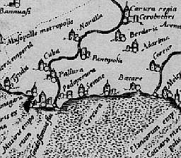
Gallery Tour, page 3 of 6. Figure Three: Ptolemy and the Southeast Coast of India |
|
|
Ptolemy did not understand the true triangular shape of India. This coast should be running north-south instead of east-west. The great trading post here was Muziris, Ptolemy has it connected by the Psuedostomus River to the Chera capital of Karur. The Cheras controlled the interior of the southern part of the peninsula and the lower West Coast. The name Psuedostomus ("false mouth or inlet") may be appropriate. Actually, the Western Ghats intervene between Muziris and Karur. Thus, there are two rivers, a short one running coastward toward Muziris and a longer one running to the interior toward Karur. Muziris was near a crucial gap in the mountains. It would have been a false inlet because no one could sail from Muziris to Karur. Just on the other side of the Palghat gap on the Noyyel River that flows past Karur was Kodumanal. This Pandukal-inhabited village or town was famous for its goldsmiths. It was also very near the important beryl deposits and well as rock crystal, sapphire and probably amethyst sources. It was a key beadmaking center, as was Arikamedu on the other side of the peninsula. However, not only is Kodumanal omitted, but also the beryl deposits have been moved, just as the Sardonyx Mountains were. See the next page. |
|
|
|
|
|
__________________________________________________ Small Bead Businesses| Beading & Beadwork | Ancient Beads | Trade Beads |